Are you looking to be inspired? Need to plan your next gravel adventure, but have no idea where to start?
Tracing a route, even in an unknown geographical area, is an operation that is increasingly within everyone's reach. It just takes a bit of enthusiasm and effort. Even though technology can give us a helping hand, do not forget that there are experts who are specialised in this field who can plan the route for you...
Gravel cycling has allowed us to rediscover the taste of adventure on two wheels, alone or in company. One-day adventures that can become real tests to try and discover the most remote places on the planet.

We have selected three software programs that have become increasingly popular over the last few years. Three solutions that offer synchronisation with the best cycle computers on the market, coupled with the relevant iOS and Android apps you will have all the necessary information always at hand.
1 - Komoot
Komoot is a program that, even in its free downloadable version, offers interesting and advanced options. The software allows you to explore a region and see the public activities of other Komoot users, who help enrich the maps by creating points of interest (highlights).
In addition to this function, there is also a route planner which, thanks to an internal algorithm, allows you to trace and plan gravel routes from point A to point B in a few seconds. In this planning phase, different filters can be set. In addition to the type of activity (there is even a profile dedicated to gravel), you can choose the degree of difficulty of the itinerary according to your level of training. You can also select the direction of travel (one way or roundtrip).
It is also possible to move a particular way point on the map (OpenStreetMap) which can also be displayed in satellite mode. In the left column, next to the itinerary, various sections and types of road surface are proposed, divided by percentage and distance.
Komoot provides advanced features for a single region that does not take into consideration political and administrative boundaries. By taking out an annual subscription of € 59.99, Komoot gives you access to maps and navigation throughout the world, with further specific functions dedicated to each individual activity, including live tracking and weather information. Last but not least, the multi-day planner is included in the subscription, a function that can be of particular help for those bikepacking gravel enthusiasts who need to plan and organise their route thanks to the possibility of organising overnight stays.
2 - Strava
Performance and comparing yourself with friends and professional athletes on a route segment is the true nature of this program, created with the aim of sharing and monitoring sports performance in the field of endurance disciplines.
From the end of 2016 Strava began to offer the routes function, but at that moment it was only available for premium users. This is where the main difference with Komoot lies. The planning and monitoring of routes that can also be viewed on a 3D satellite map (MapBox) with frames used that are no older than 24 months. Also Strava has introduced the points of interest function and allows you to set a place for a starting point (e.g. starting point - Manghen pass). It even advises the best place to park your car or set a meeting point and how to get to the indicated place.
Strava, despite everything, remains as a program that is more performance-oriented with the possibility to compare your performance with your circle of contacts. A useful tool to discover new roads and endless possibilities.
Also, not to be overlooked, is the possibility of synchronising Strava with VeloViewer (a Strava developed software also used frequently by pro cyclists) to obtain graphic reproductions, statistics and more details concerning in particular, road routes.
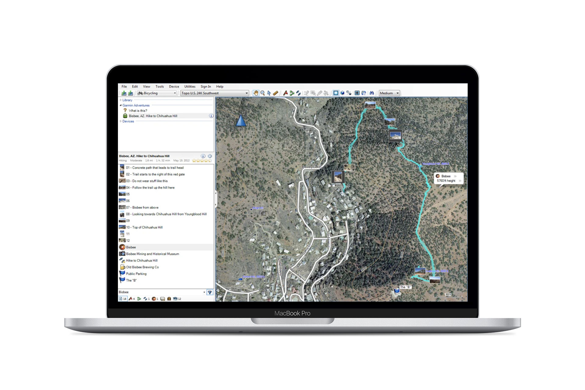
3 - Base Camp
Unlike Komoot and Strava, Base Camp is a free planning, analysis and archiving software developed and distributed by Garmin. Inevitably, as a consequence, Base Camp is best when combined with a mapping device produced by the US brand, even if the mapping can be downloaded to a PC.
The data is analysed by the software to elaborate the routes, and has different modes including bike tours. One of the strengths of Base Camp is the precise accuracy of the maps and the ability to compare different topographic maps dedicated to different disciplines and uses (hiking, road routes for cars and other vehicles, etc.). Thus, by superimposing different uses, it is possible to explore a particular territory in even more detail. Another very useful aspect is the parallel display of the 2D and 3D map and an easy and fast synchronisation with Garmin devices.